Workshop 1 and related engagement
Overview
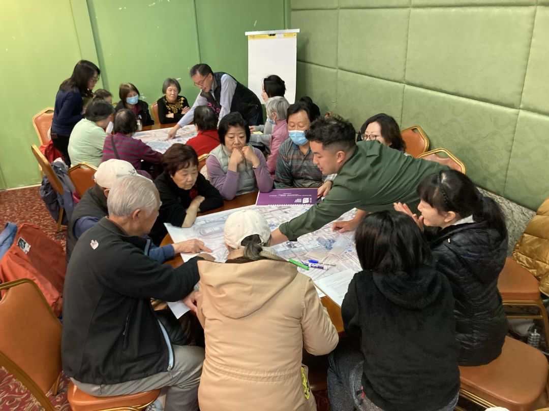
On February 28, 2024, Sound Transit and the City of Seattle co-hosted the first workshop of the South Downtown Hub (SDH) plan focused on developing overall concepts for improvements to streets and public spaces in South Downtown. More than 100 people participated in the workshop, the purpose of which was to engage the community on opportunities and solutions to connectivity between the Pioneer Square and Chinatown-International District neighborhoods, as well as existing and planned transit stations.
The workshop featured an interactive and facilitated activity that used transparency overlays and photo cards to depict urban design concepts and features. Staff introduced options and helped participants visualize and navigate the benefits and challenges of each to create a “vision board.” Notetakers captured feedback, questions, and general sentiment throughout the exercise, which is summarized on this page.
Following Workshop 1, several smaller and focused forums were held with organizations and groups throughout the community utilizing the same Workshop 1 vision board activity. Sound Transit and the City of Seattle staff met with over 100 community members, 60 of which participated in two fully Cantonese and Mandarin forums. Participants included CID and Pioneer Square residents, workers, and community members. The goal was to bring the workshop activity to the community, collecting feedback from those who have specialized connections and interests within the CID and Pioneer Square neighborhoods.
The feedback provided at the workshop and related engagement events is informing our understanding of what the community values and identifying what ideas merit future development, which will be built on in the next SDH workshop this summer.
A summary of feedback
- Interest in pedestrian streets, pedestrian lighting, café streets, information and security booths, event spaces, protected bike lanes, festival streets, street trees, activated alleys, and overhead weather protection.
- Interest in connecting to indigenous identity of place and preservation of the area’s history.
- Support for civic gathering spaces that signify the neighborhood as a gateway.
- Interest in pop-up and immediate activation of spaces with music and art.
- Support for improved connections from the CID to the waterfront and community services.
- Interest in providing bike storage, restrooms, drop-off areas, and retail at station entrances.
- Request for more wayfinding signage in the CID.
- Interest in improving expressed concerns over safety and lighting at night.
Workshop focus areas
The focus areas of key streets and public spaces that were discussed to reveal how best to connect neighborhoods and the sites of existing and potential future transit stations included:
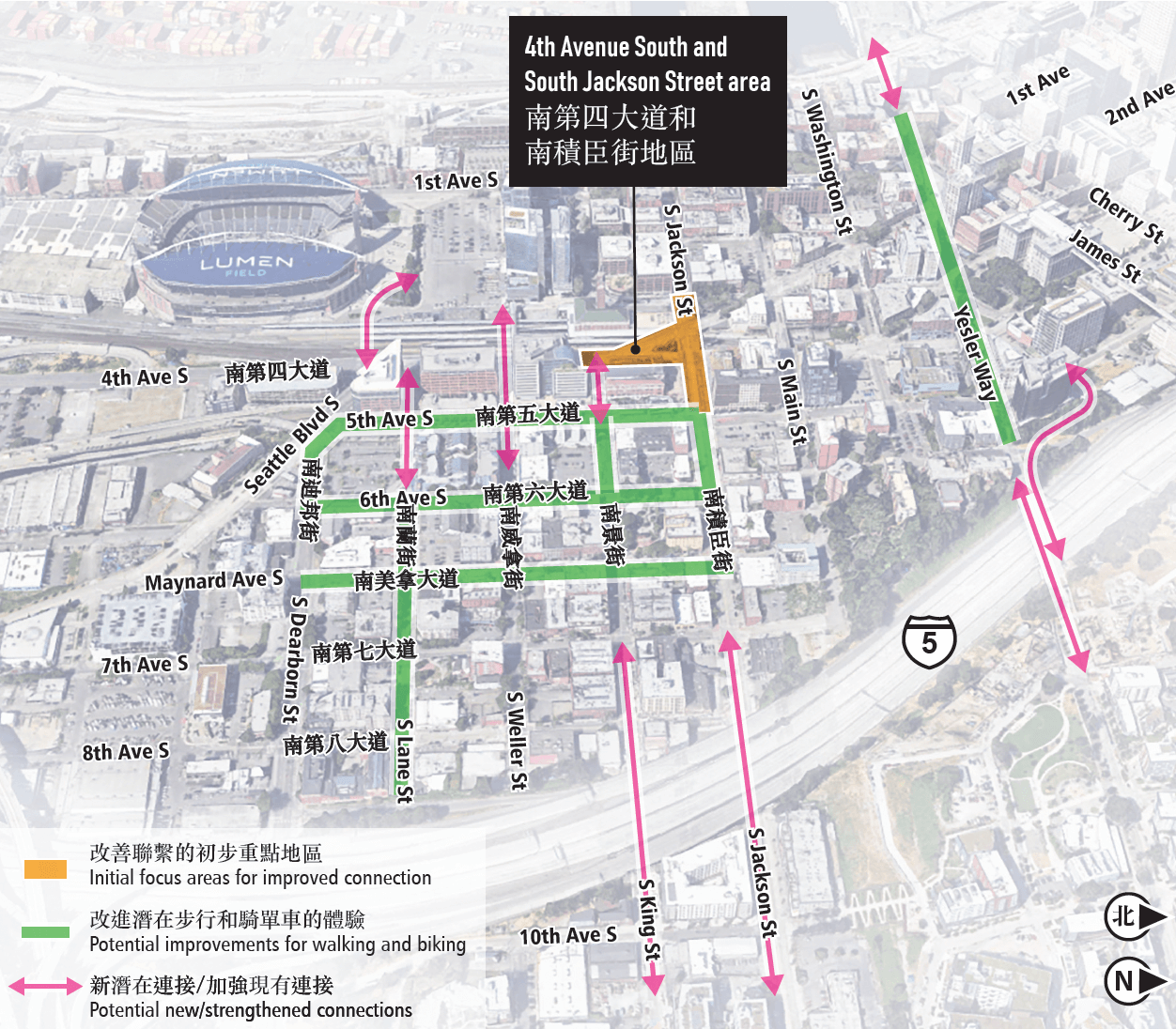
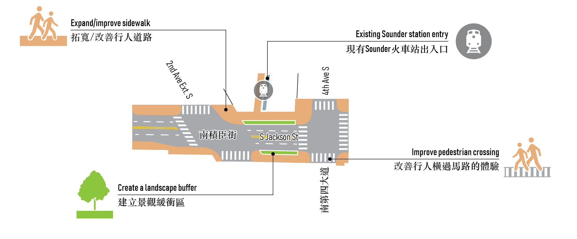
The intersection of 4th Avenue South, South Jackson Street, and the 2nd Avenue Extension is a busy and complex series of street crossings sitting between King Street Station (served by Amtrak and Sounder commuter rail) and Union Station. Past planning efforts have identified these intersections as a key barrier for mobility between Pioneer Square and the CID, as well as an opportunity to improve public spaces and strengthen connections between communities and neighborhoods.
Moving south, South Dearborn Street and the intersections of Seattle Boulevard, 4th Avenue South, 5th Avenue South, and 6th Avenue South have long felt disconnected from the CID. This auto-centric area lacks pedestrian safety and becomes congested during stadium events. Home to the Inscape Arts and Cultural Center, this area has the potential for new development and public space that serves the CID.
The following summarizes feedback specific to each focus area.
The focus in this area was to explore ways to strengthen connections between Union and King Street Stations and reduce barriers caused by the configuration of transportation infrastructure between the CID and Pioneer Square.
Workshop and roadshow participants considered ways these streets and public spaces could be improved to better serve these historic neighborhoods.
A summary of feedback
- The South Jackson Street adjustment option improves sidewalk space, adds pedestrian scale lighting, adds planters, and adjusts signal timing to allow for more time to cross the street from King Street to Union Station.
- Support for the South Jackson Street railroad lid option to cover the open triangle to the south of Jackson Street and around the Sounder entry for easier access to the trains and provide planning and improved pedestrian space.
- Interest in people-first intersections, street trees, wayfinding elements, personalized streets, café streets, overhead protection, pedestrian lighting, an information and security booth, and event space in this area.
- Suggest more amenities and shops were needed north of South Jackson Street.
- Suggest a roundabout to remediate congestion at 4th Avenue South and South Jackson Street.
- Interest in maintaining the streetcar on South Jackson Street.
“When you see a reduced focus on cars, you see more people come to liven the space up and open it up to other uses.” – Participant at Workshop 1 event on Feb. 28, 2024
Street adjustment option at South Jackson Street
Potential Benefits
- Better walking and rolling experience on South Jackson Street and 4th Avenue South.
- Better connections to regional transit.
- More accessible crossings for pedestrians.
Potential Challenges
- Construction in roadway could constrict vehicle traffic and access to neighborhoods.
- Roadway redesign will be limited by street car and capacity.
- Planters/modifications around the openings over the railway will require review by the railway and by the historical boards.
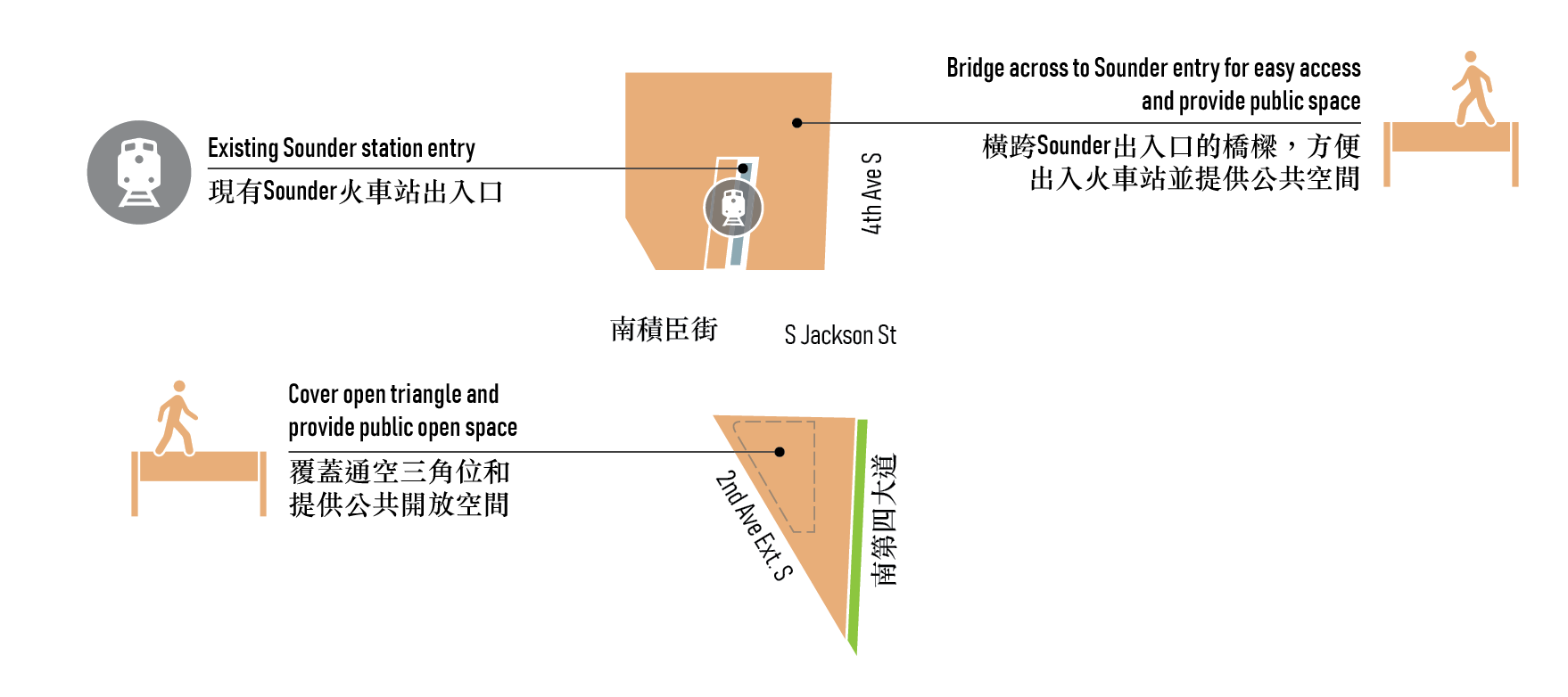
Public space improvement option — Bridging to Sounder
Potential Benefits
- Better walking and rolling experience on South Jackson Street and 4th Avenue South.
- Better connections to regional transit.
- Safer and more accessible crossings.
Potential Challenges
- Construction near the roadway could cause disruption to traffic during implementation.
- Ability to build over openings over the railway will require review by the railway and by the historical boards.
- During construction, access to the Sounder platform may be constricted.
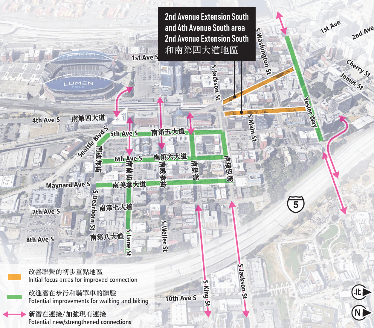
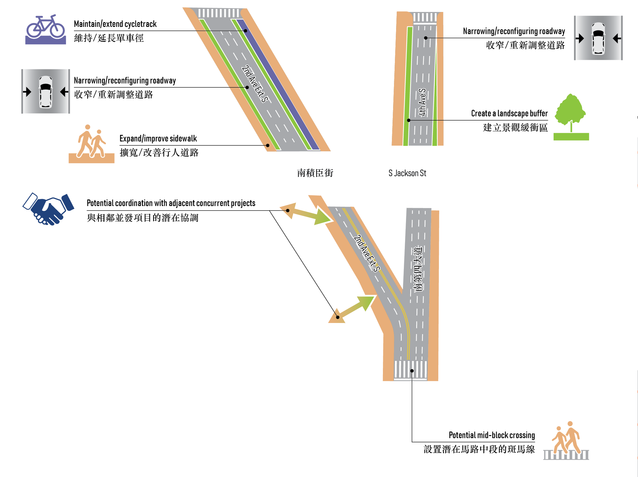
The focus in this area was to think about the experience along 2nd Avenue Extension South and 4th Avenue South between South Jackson Street and Yesler Way.
Workshop and roadshow participants considered ways these streets could support a more pleasant walking environment and help tie together existing neighborhoods, potential new development, and transit stations.
A summary of feedback
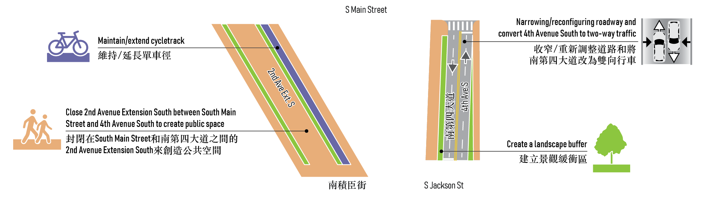
- Interest in the 2nd Avenue Extension South and 4th Avenue South Street transformation option 2. This option closes the 2nd Avenue Extension South segment to create public space for residents of the neighborhoods. This requires adjacent segments of 4th Avenue South to be converted to two-way traffic to alleviate traffic on the street grid.
- Interest in pedestrianized streets, café streets, protected bike lanes, overhead protection, pedestrian lighting, a festival street, and public plazas or parks in this area.
- Keep 2nd Avenue Extension South open for buses only.
- Interest in bus routes and functionality.
- Concern about primary movement through and not to the neighborhood (i.e., using this area to get from one place to the next).
- Suggest street condition improvements on Maynard Avenue South between South Jackson and South Main streets.
- In favor of more bike and pedestrian protection from cars and traffic on the 2nd Avenue Extension.
- Interest in operating a pedestrian lane on the weekdays and activating the space on the weekends.
- Interest in closing the 2nd Avenue Extension to support better access to the ferries.
“The closure of 2nd feels safer and more connected to the waterfront.” – Participant at Puget Sound Sage community forum event on April 16, 2024
Street adjustments option — 2nd Avenue Extension South and 4th Avenue South
Potential Benefits
- Widened sidewalks support pedestrian access and movement.
- Trees and plantings protect space for walking, rolling, and biking.
- Increased pedestrian activity encourages access to multiple storefronts on a street.
Potential Challenges
- Implementation might include shut down of lane(s) during construction, temporarily constricting vehicle traffic and access in the area.
- Potential reduction in on-street parking and loading.
- Potential reconfiguration of the bus island.
- Possible new signals and/or signal timing and reconfiguration of traffic flows to lessen traffic on strolling streets.
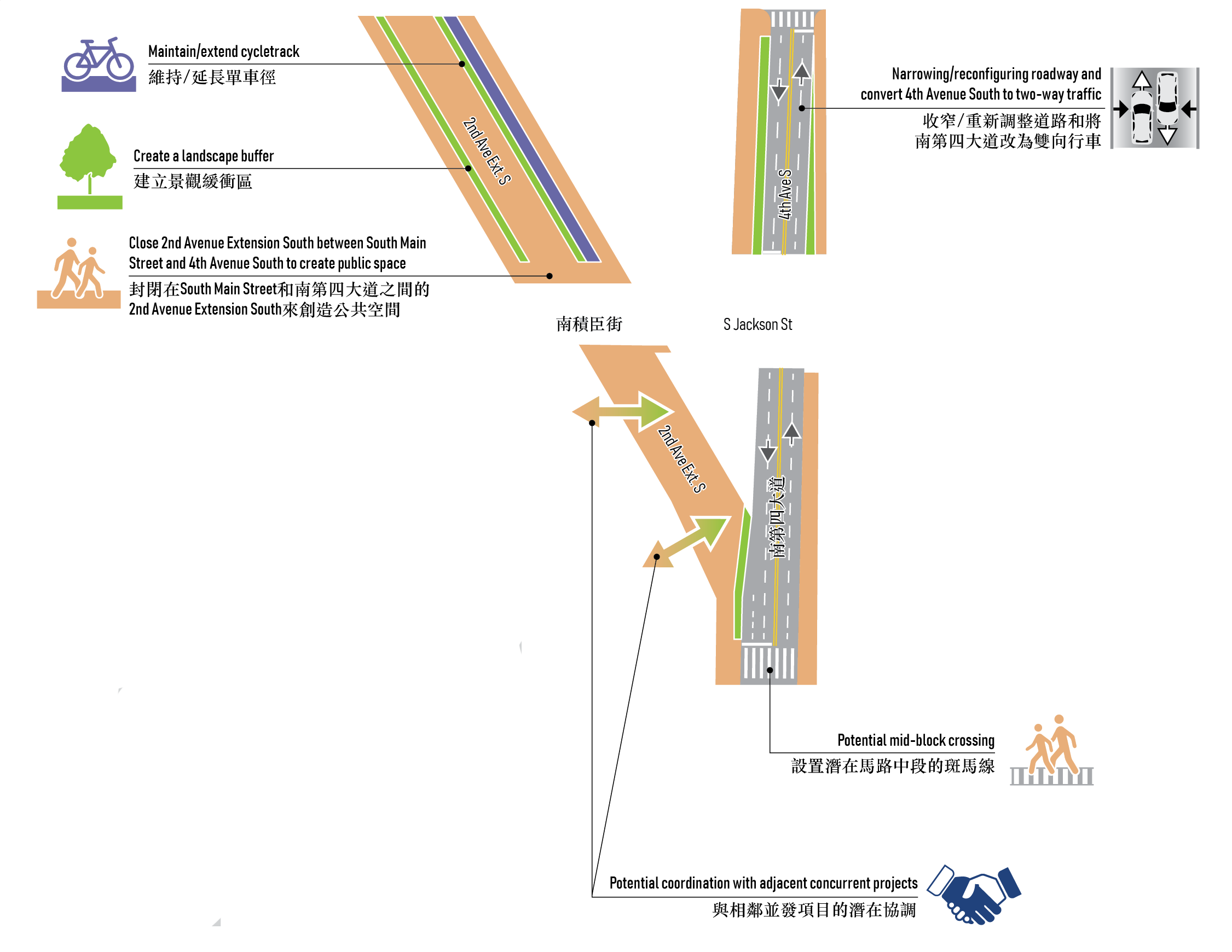
Street transformation option 1 — 2nd Avenue Extension South and 4th Avenue South
Potential Benefits
- Better walking and rolling experience on South Jackson Street and 4th Avenue South.
- Better connections to regional transit.
- Calmer, simplified intersection.
- Enhanced and expanded open space for neighborhoods.
- Opportunity to enhance and leverage concurrent projects into a single improvement project and phase.
Potential Challenges
- During construction vehicle traffic and access to neighborhoods may be constricted.
- New signals and reconfiguration of traffic flows & patterns would need to be considered throughout the area.
- Different funding timelines and agency project requirements may be challenging to align.
- Requires conversion of 4th Avenue South to two-way south of South Main Street.
Street transformation option 2 — 2nd Avenue Extension South and 4th Avenue South
Potential Benefits
- Better walking and rolling experience on South Jackson Street and 4th Avenue South.
- Better connections to regional transit.
- Calmer, simplified intersection.
- Potential for more active ground floor uses in adjacent buildings.
- Opportunity to enhance and leverage concurrent projects and studies.
Potential Challenges
- During construction, vehicle traffic and access to neighborhoods may be constricted.
- New signals and reconfiguration of street grid and traffic flows would need to be considered throughout the area.
- Potential reduction in on-street parking and loading.
- Requires conversion of 4th Avenue South to two-way on adjacent segments.
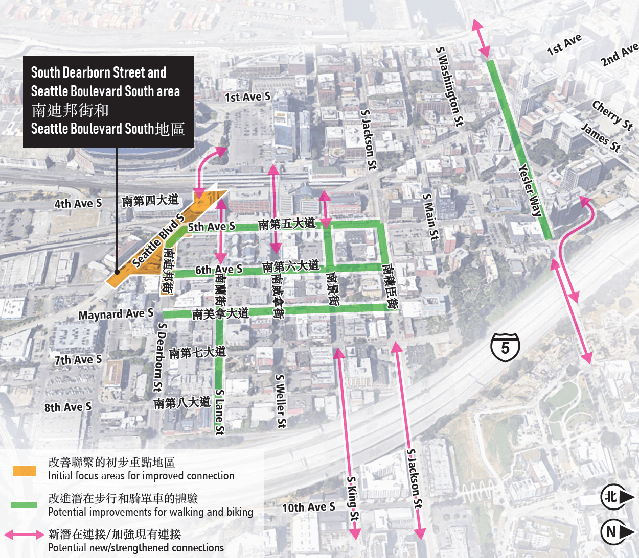
The focus in this area was to think about the function and design of streets to create more public space and walkable connections in the south end of the CID with the potential for additional opportunities to connect to Pioneer Square and to Amtrak and Sounder trains. This area is home to the Inscape Arts and Cultural Center but is currently separated from the CID by arterial streets and auto-oriented uses.
Workshop and roadshow participants considered new street configurations and public space that could expand the boundaries of the CID. Ideas discussed could provide space for new growth and development that strengthens the neighborhood without displacing existing residents and businesses.
A summary of feedback
- Interest in the South Dearborn Street transformation option that would transform South Dearborn Street at the intersection of Seattle Boulevard South into a shared space that prioritizes pedestrian uses and movement. This option improves the pedestrian experience by expanding the sidewalks between 6th Avenue South and 7th Avenue South and encourages vehicles to turn early.
- Some interested in the South Dearborn Street adjustment option that would expand sidewalks and eliminate the right turn lane on 5th Avenue South.
- Interest in public space improvement option, regardless of where the future station location would be, that would create a new pedestrian bridge that would connect between 4th Avenue South, the Sounder station platform, and the Stadium District.
- Interest in places to sit, parks and greenspace, a pedestrian bridge, street trees, community-led development, community-activated historic buildings, and district parking with active ground floor in this area.
- Support for residential development (prioritizing affordable housing) south of South Dearborn Street and Inscape Arts and Cultural Center.
- Interest in increasing the number of amenities and shops in this area.
- Concern that this area does not feel safe to walk through.
- Interest in exploring public realm activation on South Dearborn Street, but this comes with a concern about circulation effects. Workshop participants called for a traffic circulation study.
- Concerns over eliminating the Shell gas station. It is the only gas station in this area and nicotine and personal hygiene products are difficult to locate in the CID.
- Interest in underground pedestrian walkways versus street level connections between a Dearborn Station and the existing CID Station.
“Improving pedestrian walkways in the Dearborn area would improve tour safety and walkability to Inscape.” – Participant at the Wing Luke Museum community forum event on May 3, 2024
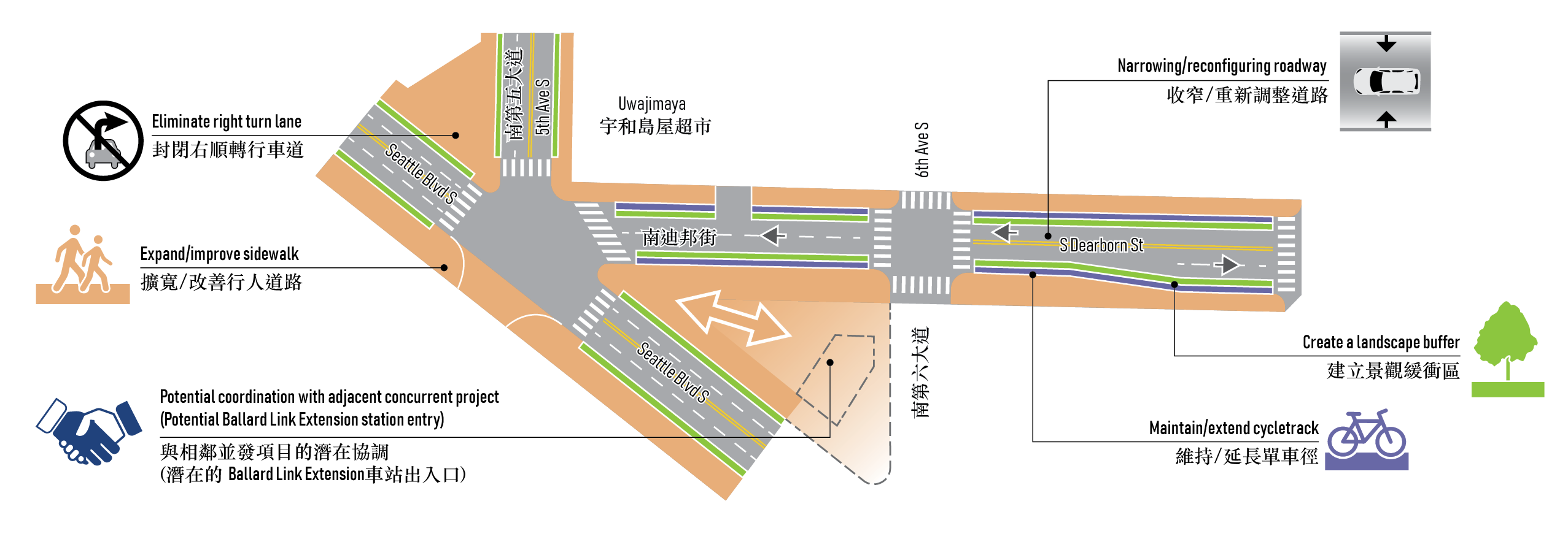
Street adjustments option—South Dearborn Street and Seattle Boulevard South
Potential Benefits
- More pleasant walking and rolling experience on Dearborn.
- Better connection between Chinatown neighborhood core and potential future development hub.
- More pleasant walking experience on Seattle Boulevard South.
- Maintains current freight access.
Potential Challenges
- Construction might constrict vehicle traffic and access to some destinations in neighborhood.
- Possible new signals and/or signal timing and reconfiguration of traffic flows constricted.
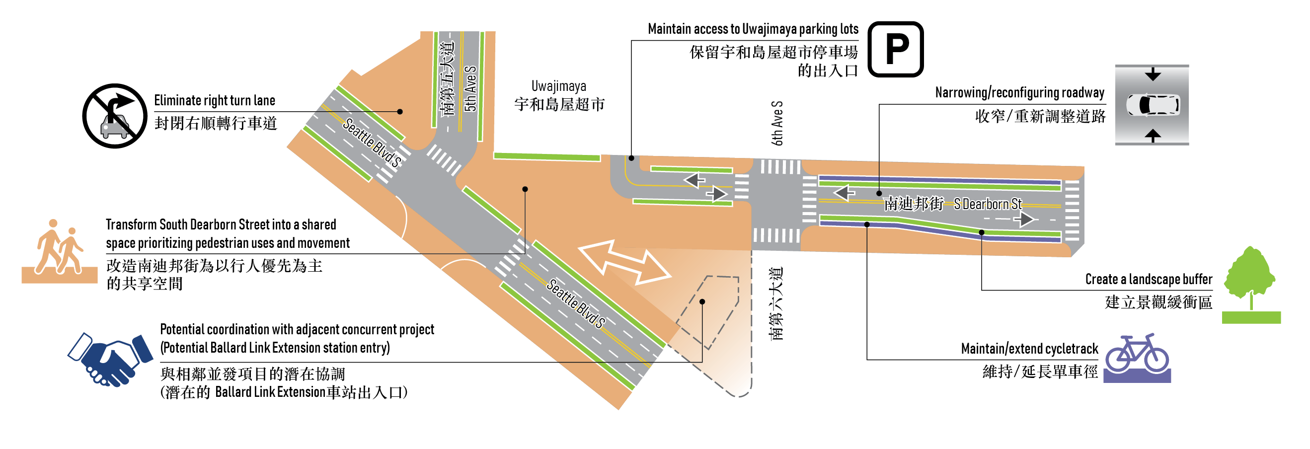
Street transformation option—South Dearborn Street and Seattle Boulevard South
Potential Benefits
- More pleasant walking and rolling experience on South Dearborn Street.
- Better connection between Chinatown neighborhood core and future development hub to encourage access to local shops and restaurants.
- More pleasant walking experience on Seattle Boulevard South.
- More open space/green space.
- Opportunity to enhance and leverage concurrent projects (Ballard Link Extension - Preferred Alternative CID Station).
Potential Challenges
- During construction, vehicle traffic and access to neighborhood destinations may be constricted.
- Potential need to adjust traffic signal timing and redirect through traffic flows to Seattle Boulevard South, particularly freight traffic.
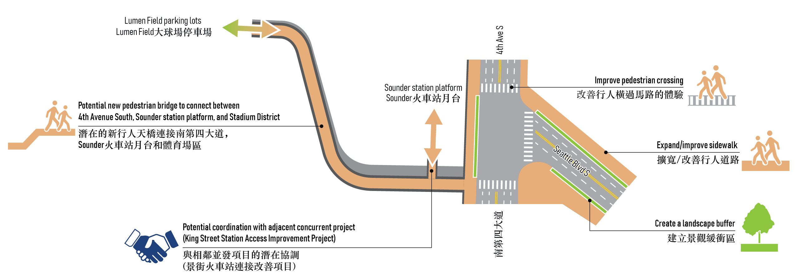
Public space improvement option—South Dearborn Street and Seattle Boulevard South
Potential Benefits
- Additional pedestrian connection from CID to Pioneer Square via Stadium district.
- Additional crossing option of 4th Avenue South improves access and safety.
- Opportunity to enhance and leverage concurrent projects (King Street Station Access Improvement Project).
Potential Challenges
- Landing of pedestrian bridge would alter existing green space and/or circulation through parking lots.
- New bridge may require review by the railway and historical boards.
Worshop 1 materials
- South Downtown Hub Workshop 1 Activity Guide:
[English + Traditional Chinese]
[Simplified Chinese]
[Vietnamese] - South Downtown Hub Workshop 1 Ballard Link Extension Packet